Synopsis:
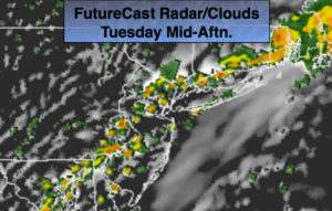
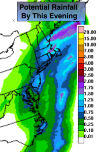
Florence, which is now an area of low pressure located over Southern NY State will move toward the East North East today. On and off rain and possible storms are expected today, meaning there could be a few hours of dry time in between the waves of rain. The rain could be torrential at times. Up to an additional inch or so of rain is possible in spots (map above). The remnants of Florence brought up a tropical airmass; It’ll be very humid.
The threat of rain should taper off from Northwest to Southeast as the afternoon continues. The sun could make an appearance.
High pressure will move in tomorrow. The humidity will be much lower with plenty of sunshine. Fine September weather will be with us through Friday.
You know where to find a no hype, no nonsense forecast.
Stay tuned.
Today:
On and off rain and isolated thunderstorms. Humid. Locally heavy rain possible. There will be dry times. Highs in the upper 70s. Southwest to North wind at 5-10mph.
Tonight:
Mostly clear with lowering humidity. Lows in the upper 60s in the City, near 60º inland. North wind at 5mph.
Wednesday:
Mostly sunny. Much less humid. Highs around 80º.
Thursday:
Mostly sunny, cooler. Highs in the mid 70s.
Friday:
Partly sunny. Much warmer. Highs in the lower to mid 80s.
Saturday:
Partly sunny. Highs in the mid 70s.
Keep it here for a no nonsense, no hype forecast.