Synopsis:
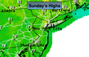
Any patchy early morning fog will give way to sunny skies. High pressure will be in control over the Northeast. Temperatures will be a few degrees above the average of 78º. It will be a spectacular day. Rough surf and dangerous rip currents will definitely will continue to be an issue.
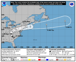
Tropical Storm Florence has weakened to a depression. Extreme rainfall amounts will continue to occur over parts of North and South Carolina. A catastrophic flooding event has occurred. 20″-40″ of rain has and will fall in spots.
Florence will then turn up the spin of the Appalachians Monday. The remnants of Florence will affect the area on Tuesday. Periods of rain and scattered thunderstorms are possible. Torrential rain is possible at times.
Fine September weather will follow Wednesday through Friday.
You know where to find a no hype, no nonsense forecast.
Stay tuned.
Today:
Patchy early morning fog, otherwise, mostly sunny. Highs in the lower 80s. Northeast to Southeast winds at 5mph.
Tonight:
Partly cloudy. Lows in the 60s. The upper 50s well inland. Light Southeast wind.
Monday:
Any morning sun will give way to clouds. Becoming humid. Highs around 80º.
Tuesday:
Periods of rain and thunderstorms. Humid. Locally heavy rain possible. There will be dry times. Highs in the upper 70s.
Wednesday:
Sunny. Highs around 80º.
Thursday:
Partly sunny. Highs in the mid 70s.
Keep it here for a no nonsense, no hype forecast.