Synopsis:
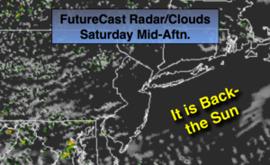
Clouds will give way to partly sunny skies today. The weekend looks decent with seasonal temperatures and a fair amount of sunshine as high pressure finally takes control over the Northeast and dries the atmosphere out. Rough surf and dangerous rip currents will definitely be an issue because of Tropical Storm Florence.
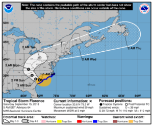
Tropical Storm Florence continues to drift West through Eastern South Carolina.
Florence will continue to weaken and will be downgraded to a tropical depression tonight. Extreme rainfall amounts will occur over parts of North and South Carolina. A catastrophic flooding event is likely. 20″-40″ of rain will fall in spots.
Florence will then turn up the spin of the Appalachians Monday. The remnants of Florence will most likely affect the area on Tuesday. Periods of rain and scattered thunderstorms are possible.
You know where to find a no hype, no nonsense forecast.
Stay tuned.
Today:
Morning clouds and patchy fog. Becoming mostly sunny. Highs around 80º. Northeast to Southeast winds at 5mph.
Tonight:
Partly cloudy with areas of fog. Lows in the 60s. Light East wind.
Sunday:
Mostly sunny. Highs around 80º.
Monday:
Sun giving way to clouds. Highs around 80º.
Tuesday:
Periods of rain and thunderstorms. Humid. Locally heavy rain possible. Highs in the upper 70s.
Wednesday:
Partly sunny. Highs around 80º.
Keep it here for a no nonsense, no hype forecast.