Synopsis:
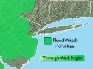
***Flash Flood Watch for much of NJ into tonight. Locally heavy rain may cause flash flooding of roadways and creeks. If you encounter a flooded roadway-TURN AROUND-DON’T DROWN***
A trough of low pressure over the Appalachians and a strong high pressure off the Eastern Seaboard will result in a very humid airmass originating from the Caribbean through today. The best chance of widespread rain and thunderstorms will be into tonight as this is the time of best forcing and convergence over the tri-state area.
By Thursday the pattern will finally begin to break down and a drier wind from the land will occur. An isolated shower is possible.
Friday and into the weekend should be mainly dry as high pressure from the West begins to take hold.
Stay tuned.
Today:
Cloudy and humid with periods of rain and scattered storms. Local downpours. It won’t be raining all the time. Highs in the upper 70s. Southeast winds 10-15mph.
Tonight:
Mostly cloudy. Hit or miss showers and storms. Local downpours. Muggy. Lows around 70º in the City, the upper 60s inland. Southeast to Southwest wind at 5mph.
Thursday:
Hazy, warm and and slightly less humid with isolated showers. Highs in the lower to mid 80s.
Friday:
Partly sunny. An isolated storm is possible later in the day or evening. Highs in the mid to upper 80s.
Saturday:
Partly sunny. Highs in the mid 80s.
Sunday:
Partly sunny. Highs in the mid 80s.
Keep it here for a no nonsense, no hype forecast.