Synopsis:
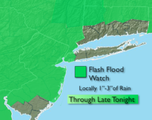
***Flash Flood Watch for most of the tri-state area through late tonight, excluding Long Island and Connecticut. Locally heavy rain may cause flash flooding of roadways and creeks. If you encounter a flooded roadway-TURN AROUND-DON’T DROWN***
The trough of low pressure over area and a strong high pressure off the Eastern Seaboard that has resulted in a Caribbean feel around here that will finally weaken by morning. The best chance of widespread rain and thunderstorms will be into tonight as this is the time of best forcing and convergence over the tri-state area.
By Thursday the pattern will finally begin to break down and a drier wind from the land will occur. A mix of sun and clouds is expected. An isolated shower is possible. The humidity will be slightly lower.
On Friday, a front will approach late in the day. A mix of sun and clouds is expected. Spotty storms are possible later in the afternoon and evening.
The weekend should be mainly dry as high pressure from the West begins to take hold.
Stay tuned.
Tonight:
Mostly cloudy. Scattered showers and storms. Local downpours. Muggy. Lows around 70º in the City, the upper 60s inland. Southeast to Southwest wind at 5mph.
Thursday:
Hazy, warm and and slightly less humid with isolated showers. Highs in the lower to mid 80s. Southwest winds at 5-10mph.
Friday:
Partly sunny. Warm and humid. An isolated storm is possible later in the day or evening. Highs in the mid to upper 80s.
Saturday:
Partly sunny. Highs in the mid 80s.
Sunday:
Partly sunny. Highs in the mid 80s.
Monday:
Partly sunny. Chance of late day showers. Highs in the mid 80s.
Keep it here for a no nonsense, no hype forecast.