Synopsis:
The pattern setup of a trough of low pressure over area and a strong high pressure off the Eastern Seaboard that had it feeling like the Caribbean has broken down. FINALLY. A drier wind from the land will occur today. This will result in a mix of sun and clouds. An isolated shower is possible. The humidity will be slightly lower.
On Friday, a front will approach late in the day. Hazy sun is expected. It’ll be more humid. Spotty storms are possible later in the afternoon and evening. Some of the storms could be strong.
The weekend should be mainly dry as high pressure from the West begins to take hold under a mix of sun and clouds. It’ll be much less humid.
Stay tuned.
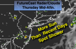
Thursday:
Hazy, warm and and slightly less humid with isolated showers. Highs in the lower to mid 80s. Southwest winds at 5-10mph.
Tonight:
Mostly clear. Muggy. Lows in the lower 70s in the City, the 60s inland. Southwest wind at 5mph.
Friday:
Partly sunny. Warm and humid. An isolated storm is possible later in the day or evening. Highs in the mid to upper 80s.
Saturday:
Partly sunny. Highs in the mid 80s.
Sunday:
Partly sunny. Highs in the mid 80s.
Monday:
Partly sunny. Chance of late day showers. Highs in the mid 80s.
Keep it here for a no nonsense, no hype forecast.