Synopsis:
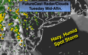
An upper level low over the Appalachians and a strong high pressure off the Eastern Seaboard will result in a flow of air from the Bahamas. It’ll be very humid with spotty showers and storms. Some of the rain maybe heavy. It won’t be a washout and a good part of the time will be dry. Mainly areas near the coast and to the East will experience very little rain at all today (map above).
The best chance of widespread rain and thunderstorms will be Wednesday as this is the time of best forcing and convergence over the tri-state area.
By Thursday the pattern will finally begin to break down and a drier wind from the land will occur. An isolated shower or storm is possible.
Friday and into the weekend should be dry as high pressure from the West begins to take hold.
Stay tuned.
Today:
Hazy, warm and humid with scattered storms, mainly over inland areas. Local downpours. Highs in the lower 80s. Southeast winds at 10-15mph.
Tonight:
Mostly cloudy. Hit or miss showers and storms. Local downpours. Muggy. Lows in the lower to mid 70s throughout. Southeast wind at 8-12mph.
Wednesday:
Cloudy and humid with periods of rain and scattered storms. Local downpours. Highs in the upper 70s.
Thursday:
Hazy, warm and humid with isolated storms. Highs in the mid 80s.
Friday:
Partly sunny. Highs in the mid to upper 80s.
Saturday:
Partly sunny. Highs in the mid 80s.
Keep it here for a no nonsense, no hype forecast.