Synopsis:
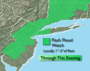
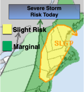
A potent cool front will move toward the area today with afternoon scattered thunderstorms. Some of the storms maybe severe with torrential rain. Much of the region is in a slight risk for severe storms this afternoon. It’ll still be very warm and humid. Please keep an eye to the sky for threatening weather after 1pm, first starting over the Northwestern parts of the tri-state then moving toward the coast (which is usually the case). A Flash Flood Watch has been posted for much of the tri-state area into this evening. If you encounter a flooded roadway-TURN AROUND, DON’T DROWN.
The storms will end later this evening and it’ll become much more comfortable overnight.
Relief will arrive by Wednesday as a refreshing area of high pressure moves in from Canada. Mostly sunny, warm conditions are expected through Friday.
Stay tuned.
Today:
Hazy,very warm and humid with scattered afternoon thunderstorms. Some of the storms maybe severe and accompanied by torrential rain. Highs in the mid to upper 80s. South to Southwest winds at 8-12mph.
Tonight:
Any thunderstorms will move offshore early, otherwise, partly cloudy and becoming less humid. Lows in the upper 60s in the City, near 60º inland. Northwest wind at 5-10mph.
Wednesday:
Mostly sunny, warm and much less humid. Highs in the mid to upper 80s.
Thursday:
Sunny. Highs in the mid 80s.
Friday:
Partly sunny. Highs in the mid 80s.
Saturday:
Partly sunny. Highs in the lower 80s.
Keep it here for a no nonsense, no hype forecast.