Synopsis:
A potent cool front will move toward the area this evening scattered thunderstorms and areas of rain. One batch of rain is moving off the coast. A broken linen of showers and storms will move in later this evening with the front.
The storms will end later this evening and it’ll become much more comfortable overnight.
Relief will arrive by Wednesday as a refreshing area of high pressure moves in from the West. Mostly sunny, warm conditions are expected through Friday.
Saturday looks pleasant with the high still in control. A southerly flow will develop around the high and bring up moisture from the South for Sunday. Showers are possible but this is not etched in stone as of this writing.
Stay tuned.
Tonight:
Scattered storms and areas of rain this evening, otherwise, partly cloudy and becoming less humid overnight. Lows in the upper 60s in the City, near 60º inland. Northwest wind at 5-10mph.
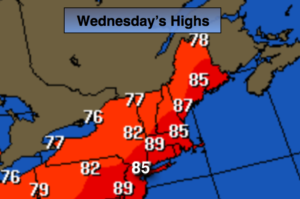
Wednesday:
Mostly sunny, warm and much less humid. Highs in the mid to upper 80s. Northwest winds at 8-12mph.
Thursday:
Sunny. Highs in the lower to mid 80s.
Friday:
Partly sunny. Highs in the mid 80s.
Saturday:
Partly sunny. Highs in the lower 80s.
Sunday:
Mostly cloudy with a chance of showers. Highs in the upper 70s.
Keep it here for a no nonsense, no hype forecast.