Synopsis:
An isolated storm is possible into this evening. Most areas will be rain-free. It’ll be warm and muggy tonight.
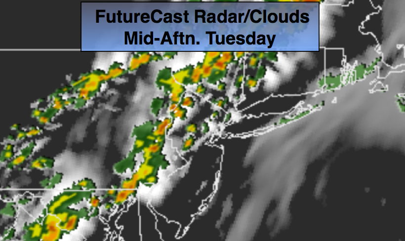
A potent cool front will move toward the area on Tuesday with afternoon scattered thunderstorms. Some of the storms maybe severe with torrential rain. It’ll still be very warm and humid. Please keep an eye to the sky for threatening weather after 1pm, first starting over the Northwestern parts of the tri-state then moving toward the coast (which is usually the case).
Relief will arrive by Wednesday as a refreshing area of high pressure moves in from Canada. Mostly sunny, warm conditions are expected through Friday.
Stay tuned.
Tonight:
An isolated storm this evening, otherwise, partly cloudy, warm and muggy. Lows in the 70s throughout. Southwest wind less than 5mph.
Tuesday:
Hazy,very warm and humid with scattered afternoon thunderstorms. Some of the storms maybe severe and accompanied by torrential rain. Highs in the mid to upper 80s. South to Southwest winds at 8-12mph.
Wednesday:
Mostly sunny, warm and much less humid. Highs in the mid to upper 80s.
Thursday:
Sunny. Highs in the mid 80s.
Friday:
Partly sunny. Highs in the mid 80s.
Saturday:
Partly sunny. Highs in the lower 80s.
Keep it here for a no nonsense, no hype forecast.