Synopsis:
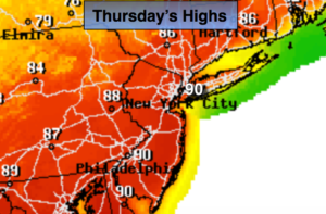
High pressure will continue to sit over the Southeast and pump up a Summery airmass through tomorrow. Today looks to be the hottest day as some areas will peak at 90º. The record at Central Park is 91º set in 2001. It’ll be close. The average high is in the mid 60s.
A Red Flag Warning has been issued central and Southern NJ. The combination of gusty winds, very low relative humidity and dry grounds may set the stage for any wildfires that develop to quickly get out of control and become difficult to contain. Please use caution outdoors with flammables.
Friday will be another July-like day with highs well into the 80s.
A cool front will move through Friday night (basically precipitation free) ending our July-like weather. More comfortable temperatures will be with us for the upcoming weekend. Saturday looks dry but by Saturday night and Sunday most of the computer models now develop a wave of low pressure along the dying cool front to the South. The chance of showers is now in the forecast for Saturday Night and Sunday.
Stay tuned.
Today:
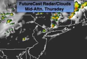
Partly sunny. Hot. An isolated late afternoon thunderstorm is possible. Highs in the upper 80s to around 90º. West to Southwest winds at 10-20mph with gusts to 30mph.
Tonight:
An isolated evening storm, otherwise, partly cloudy and warm. Lows in the upper 60s in the City, lower 60s inland. West to Southwest winds at 8-12mph.
Friday:
Partly sunny. Very warm. Highs in the mid to upper 80s.
Saturday:
Sun will give way to afternoon clouds. Much cooler. Highs in the mid 70s.
Sunday:
Mostly cloudy with scattered showers. Highs in the mid to upper 60s.
Monday:
Partly sunny and seasonal. Highs in the upper 60s.
Keep it here for a no nonsense, no hype forecast.