Synopsis:
Today will result in the trifecta of heat in early May. Records were broken yesterday. Today we’ll be just shy of the record of 92º in Central Park as the hottest part of the airmass has moved offshore. It’ll still be very warm with highs well into the 80s.
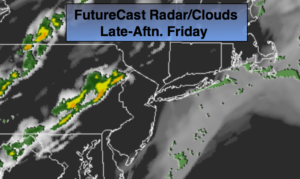
An approaching cool front will spark scattered storms later today and this evening. The majority of the afternoon will be storm-free. Some of the storms this evening maybe strong.
More comfortable temperatures will be with us for the upcoming weekend. Saturday looks dry but by Saturday night and Sunday most of the computer models develop a wave of low pressure along the dying cool front to the South. The chance of showers is remains in the forecast for Saturday Night and Sunday.
Stay tuned.
Today:
Partly sunny. Very warm. Scattered late afternoon and evening storms. Becoming windy. Highs in the mid to upper 80s. Southwest winds at 10-20mph with gusts to 30mph.
Tonight:
An isolated evening storm, otherwise, partly cloudy and becoming much cooler. Lows around 60º in the City, the 50s inland. Southwest winds becoming Northwest at 10-20mph with higher gusts.
Saturday:
Sun will give way to afternoon clouds. Much cooler. Highs in the lower to mid 70s.
Sunday:
Mostly cloudy with scattered showers. Highs in the mid to upper 60s.
Monday:
Partly sunny and seasonal. Highs in the upper 60s.
Tuesday:
Sunny. Highs around 70º.
Keep it here for a no nonsense, no hype forecast.