
Synopsis:
High pressure will continue to build over the Southeast and pump up a Summery airmass today through Friday. Temperatures will soar well into the 80s. Thursday looks to be the hottest day as some areas will peak at 90º. The average high is in the mid 60s.
A Red Flag Warning has been issued for NJ & Eastern PA. The combination of gusty winds, very low relative humidity and dry grounds may set the stage for any wildfires that develop to quickly get out of control and become difficult to contain. Please use caution outdoors with flammables.
A cool front will move through Friday night ending our July-like weather. More pleasant Spring weather will be with us for the upcoming weekend.
Stay tuned.
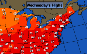
Today:
Sunny, breezy and warm. Highs in the mid 80s. West to Southwest winds at 10-20mph with gusts to 30mph.
Tonight:
Clear and warm. Lows in the upper 60s in the City, around 60º inland. West to Southwest winds diminishing to 5mph.
Thursday:
Partly sunny. Hot. Highs in the upper 80s to around 90º.
Friday:
Partly sunny. Very warm. Highs in the mid 80s.
Saturday:
Partly sunny and pleasant. Highs in the mid 70s.
Sunday:
Partly sunny and more seasonal. Highs in the mid to upper 60s.
Keep it here for a no nonsense, no hype forecast.