Synopsis:
The upper level low responsible for our Fall-like weather will continue spin over the region through today. A nip will be in the air along with a few spotty showers today.
A DRAMATIC change in the weather will occur on Tuesday as the low pulls away and high pressure builds over the Southeast. Temperatures will soar will into the 70’s for May’s debut. A Summer preview will greet us by mid to late week. Highs may approach 90º by Thursday.
Stay tuned.
Today:
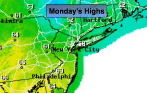
Clouds and sun, chilly with scattered showers. Highs in the mid to upper 50s. Northwest winds at 10-20mph with gusts to 25mph.
Tonight:
Becoming mostly clear late. Lows in the upper 40s in the City, the 30s inland. West to Northwest diminishing to 5mph.
Tuesday:
Sunny. Much Warmer. Highs in the mid 70s.
Wednesday:
Sunny. Warm. Highs in the lower to mid 80s.
Thursday:
Partly sunny. Hot. Highs in the upper 80s.
Friday:
Partly sunny. Very warm. Slight chance of an afternoon storm. Highs in the mid to upper 80s.
Keep it here for a no nonsense, no hype forecast.