Synopsis:
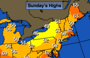
Today will be the colder half of the weekend as a cold pool of air settles over the Northeast. A shower is possible over Eastern sections this morning otherwise a mix of clouds and sun is expected. Readings will only be in the 50s. The average high this time of the year is in the mid 60s.
The upper level low will stall over the area on Monday resulting in fall-like readings and a spotty afternoon showers.
A DRAMATIC change in the weather will occur on Tuesday as the low pulls away and high pressure builds over the Southeast. Temperatures will soar will into the 70’s for May’s debut. A Summer preview will greet us by mid to late week. Highs may approach 90º by Thursday.
Stay tuned.
Today:
A morning shower East, otherwise, clouds and sun, breezy and much cooler . Highs in the lower to mid 50s. West to Northwest winds at 10-20mph with gusts to 30mph.
Tonight:
Partly cloudy. Lows in the lower 40s in the City, the 30s inland. Winds becoming West to Northwest at 10-15mph.
Monday:
Clouds and sun, chilly with scattered afternoon showers. Highs in the mid 50s.
Tuesday:
Sunny. Much Warmer. Highs in the mid 70s.
Wednesday:
Sunny. Warm. Highs in the lower to mid 80s.
Thursday:
Partly sunny. Hot. Highs in the upper 80s.
Keep it here for a no nonsense, no hype forecast.