Synopsis:
High pressure will nose in from Canada with chilly readings but more sunshine for this weekend. Daylight Saving time begins 2AM Sunday. We Spring ahead-turn your clocks ahead one hour. It’s also a good time to change the batteries in your smoke and carbon monoxide detectors.
A storm will be on the map on Sunday over the Southern states. Will that storm move out the sea to the South or will it take a turn up the coast? Most of the computer models take this storm harmlessly out to sea. A few of the model ensembles have the storm skirting our area Monday and Monday night with snow. Confidence has increased that the storm will stay far enough offshore to spare the area of a significant snowstorm. The low threat of the storm affecting the tri-state remains. Coastal areas may get grazed by the storms snow shield, but it shouldn’t add up to much, if it even happens.
Whatever the case, it will be cold and breezy behind this system into midweek next week with scattered flurries.
Stay tuned.
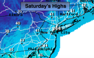
Today:
Partly sunny. Breezy. Highs in the mid 40s. West winds at 10-20mph.
Tonight:
Mostly clear. Lows near freezing in the City, the 20s inland. Northwest winds at 5-10mph.
Sunday:
Partly sunny. Highs in the mid 40s.
Monday:
Mostly cloudy. Low threat for some snow. Highs in the upper 30s.
Tuesday:
Clouds and sun, breezy and chilly. Scattered flurries. Highs around 40º.
Wednesday:
Clouds and sun, breezy and chilly. Scattered flurries. Highs in the upper 30s.
Keep it here for a no nonsense, no hype forecast.