Synopsis:
An upper level low moving off the coast this evening will cause spotty showers. Most areas North of the City will be dry. Skies will clear during the night and winds will diminish. Temperatures will drop rapidly inland. A Frost advisory is up for Morris, Somerset, Hunterdon and Ocean counties.
High pressure will move in Friday and Saturday with mainly sunny skies and slightly above average temperatures.
A potent cold front and developing storm along the coast will result in rain Sunday. The rain could be heavy at times during the afternoon. Strong winds are in the forecast once the storm departs on Monday.
Stay tuned.
Tonight:
Spotty showers South and East of the City this evening, otherwise, clearing from West to East. Lows in the mid to upper 40s in the City, the 30’s inland with patchy frost. Northwest winds diminishing to at 5-10mph.
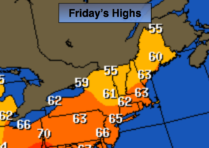
Friday:
Mostly sunny. Highs in the lower to mid 60s. West to Southwest winds at 5-10mph.
Saturday:
Partly sunny. Highs in the upper 60s.
Sunday:
Rain. The rain could be heavy at times during the afternoon. Breezy. Highs in the mid to upper 60s.
Monday:
Becoming partly sunny, windy and cooler. Highs in the mid 50s.
Halloween:
Partly sunny, breezy and cool. Highs in the upper 50s.
Keep it here for a no nonsense, no hype forecast.