Synopsis:
A front stalled just off the coast in combination with a a developing low will cause occasional showers today East of the City. A the same time a cool pool of air will work in from the North. Highs will be at or slightly below average for a change a mix of clouds and some sun. The average high is 61º
High pressure will move in Friday and Saturday with mainly sunny skies and slightly above average temperatures.
A potent cold front and developing storm along the coast will result in rain developing Sunday. The rain could be heavy at times during the afternoon. Winds could become strong depending on the storm track. Strong winds are in the forecast once the storm departs on Monday.
Stay tuned.
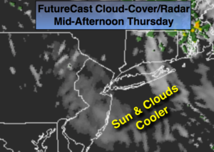
Today:
Clouds and sun. Spotty showers are possible East of the City. More seasonal. Highs in the upper 50s. Northwest winds at 10-15mph.
Tonight:
Clearing from West to East. Lows in the upper 40s in the City, the 30’s inland with patchy frost. Northwest winds diminishing to at 8-12mph.
Friday:
Mostly sunny. Highs in the lower to mid 60s.
Saturday:
Partly sunny. Highs in the upper 60s.
Sunday:
Thickening clouds. Rain developing. The rain could be heavy at times during the afternoon. Windy. Highs in the mid to upper 60s.
Monday:
Morning rain possible. Becoming partly sunny, windy and cooler. Highs in the mid 50s.
Keep it here for a no nonsense, no hype forecast.