Synopsis:
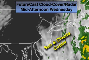
The front will continue pushing East today. spotty showers will be confined to Eastern eastern areas in the morning otherwise skies will be partly sunny for the City and farther West. Readings will be five to seven degrees above average. The average high is 61º.
A cool pool of air will work in for Thursday. Highs will be at or slightly below average for a change under partly sunny skies.
High pressure will move in Friday and Saturday with mainly sunny skies and slightly above average temperatures.
A potent cold front and developing storm along the coast will result in rain developing Sunday.
Stay tuned.
Today:
Spotty showers East, otherwise partly sunny. Cooler. Highs in the mid to upper 60s. Northwest 5-10mph.
Tonight:
Showers possible East of the City, otherwise partly cloudy. Lows around 50º in the City, near 40º inland. Northwest winds at 5-10mph.
Thursday:
Partly sunny. More seasonal. Highs in the upper 50s.
Friday:
Mostly sunny. Highs in the lower to mid 60s.
Saturday:
Partly sunny. Highs in the mid 60s.
Sunday:
Thickening clouds. Rain developing. Highs in the mid 60s.
Keep it here for a no nonsense, no hype forecast.