Synopsis:
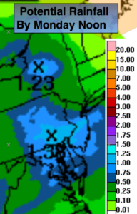
A stationary front over the region and an area of low pressure moving along the boundary will result in scattered showers and storms tonight into Monday morning. Heavy rain is possible. Flash flooding may occur in areas of heaviest rain. The map above shows the possible rain amounts by Noon Monday.
A cool front will move into the area on Monday continuing the on and off threat of showers and storms under mainly cloudy skies. It’ll be much cooler.
The weather will improve in steps midweek. A spot storm can’t be ruled out on Tuesday with an upper level trough moving through. Wednesday will be a gem abundant sunshine and low humidity as high pressure moves in.
Warmer and more humid conditions will return by weeks end with a scattered storm threat by Friday.
Stay tuned.
Tonight:
Scattered showers and thunderstorms. Torrential rain is possible. Lows in the 60s throughout. East to Northeast winds at 8-12mph.
Monday:
Mostly cloudy with a period of steady and heavy rain possible early in the morning. Spotty storms are possible during the afternoon. Cool with highs only in the lower to mid 70s. Northeast winds at 8-12mph.
Tuesday:
Mostly cloudy with spotty showers and storms during the afternoon. Highs in the mid to upper 70s.
Wednesday:
Sunny and pleasant. Highs around 80º.
Thursday:
Partly Sunny. Highs in the lower 80s.
Friday:
Partly Sunny, more humid. Scattered afternoon storms. Highs in the mid 80s.
Keep it here for a no nonsense, no hype forecast.