Synopsis:
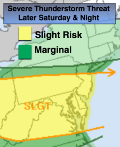
If the temperature hits 90º or higher today it will be day 4 of the heat wave for the area. The humidity won’t be nearly as oppressive but we’ll have to pay the price as a complex of thunderstorms moves out of the Ohio Valley and into parts of the area later today and tonight. The majority of the day will be hazy. There is a risk of severe thunderstorms for much of the area with the highest risk to the South of the City (map above). Severe thunderstorms contain winds in excess of 58mph or higher and or one inch hail. Keep an eye to the sky for threatening weather later today. Torrential rain is also possible with any of the thunderstorms through early Sunday morning.
The weak front will stall just South of the City on Sunday. This will result in much cooler readings but also keep the skies mainly cloudy. The complex of thunderstorms will move off the coast in the morning. A spot shower or thunderstorms can’t be ruled out during the afternoon, but much of the PM hours will be dry.
The final push of cooler and drier air will work in later Monday with a front working in from the West. Again, scattered showers and storms are possible but much of the time will be dry.
Tuesday and Wednesday will be late July gems with plenty of sunshine, low humidity and tolerable temperatures.
Stay tuned.
Today:
Hazy, hot and moderately humid.. Highs around 90º. Scattered afternoon and evening storms. Some of the storms maybe severe. East to Southeast wind at 5-10mph.
Tonight:
Scattered showers and thunderstorms. Some of the storms may contain damaging winds, hail and torrential rain. Lows around 70º in the City, the 60’s inland. East to Northeast winds at 5-10mph.
Sunday:
Mostly cloudy with scattered morning storms. Much cooler. A stray afternoon storm can’t be ruled out. Highs in the lower 80s.
Monday:
Mostly cloudy with spotty showers and storms. Highs around 80º.
Tuesday:
Partly sunny and pleasant. Highs in the lower 80s.
Wednesday:
Sunny. A top ten day. Highs in the lower 80s.
Keep it here for a no nonsense, no hype forecast.