Synopsis:
A persistent Northwest flow around a large upper level storm East of Maine will keep temperatures below normal through Friday. The average high is around 70º. A mix of sun and clouds is expected. Warm air over the mid-section of the country won’t have a chance to move East.
The computer models have a storm on the map for this weekend. The system will affect the region Saturday into Mother’s Day Sunday with rain. The potential has increased for heavy rain on Saturday. Hopefully the storm will pull out to salvage a part of Mother’s Day with afternoon sun.
Stay tuned.
Today:
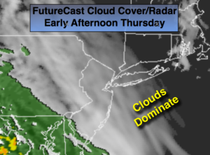
More clouds than sun (FutureCast Cloud Cover/Radar above). Highs in the lower to mid 60s. Northeast to Southeast winds at 5-10mph.
Tonight:
Mostly cloudy. Lows around 50º in the City, the 40s inland. Southeast to Northeast winds at 5mph.
Friday:
Partly sunny. Highs in the lower 60s.
Saturday:
Rain likely, very cool. Highs in the mid 50s.
Mother’s Day (Sunday):
Morning rain, otherwise, some breaks of afternoon sun. A few showers are possible during the afternoon. Highs in the lower 60s..
Monday:
Partly sunny. Highs in the mid to upper 60s.
Keep it here for a no nonsense, no hype forecast.