Synopsis:
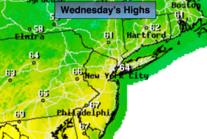
A persistent Northwest flow around a large upper level storm East of Maine will keep temperatures below normal through the week. The average high is around 70º. A mix of sun and clouds is expected through Friday. Warm air over the mid-section of the country won’t have a chance to move East.
The computer models have a storm on the map for this weekend. It now looks like the system will affect the region Saturday into Mother’s Day Sunday with rain. Believe me, I need to change this forecast or I’ll be running behind trees while venturing out.
Stay tuned.
Today:
Partly sunny. Highs in the lower to mid 60s. North wind at 5-10mph.
Tonight:
Partly cloudy. Chilly. Lows around 50º in the City, near 40º inland. Light and variable winds. Light and variable winds.
Thursday:
Partly sunny. Highs in the lower to mid 60s.
Friday:
Mostly cloudy. Highs in the lower 60s.
Saturday:
Rain likely, very cool. Highs in the upper 50s.
Mother’s Day (Sunday):
Morning rain, otherwise, some breaks of afternoon sun. Highs around 60º.
Keep it here for a no nonsense, no hype forecast.