Synopsis:
A persistent Northwest flow around a large storm in Eastern Canada will keep temperatures well below normal through the week.
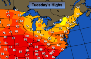
The atmosphere will begin to relax today through the end of the week meaning more in the way of sunshine with readings almost ten degrees below average. The average high is around 70º. The map above shows warm air over the mid-section of the country. That bubble of warmth will stay put with the jet stream coming out of Canada.
The computer models have a storm on the map for next weekend. Will it affect our area? The details are sketchy at this time, but be aware the threat of rain exists.
Stay tuned.
Today:
Partly sunny. Highs around 60º. Northwest wind at 5-10mph.
Tonight:
Partly cloudy. Chilly. Lows in the upper 40s to around 50º in the City, the 30s inland. Light and variable winds.
Wednesday:
Partly sunny. Highs in the lower to mid 60s.
Thursday:
Partly sunny. Highs in the lower to mid 60s.
Friday:
Partly sunny. Highs in the lower to mid 60s.
Saturday:
Mostly cloudy. Chance of rain. Highs in the lower 60s.
Keep it here for a no nonsense, no hype forecast.