Synopsis:
A persistent Northwest flow around a large storm in Eastern Canada will keep temperatures well below normal through the upcoming week. The coldest air will be over the region through tonight. After some morning sun, clouds will roll in today. Spotty showers are likely once again.
The atmosphere will begin to relax Tuesday through the end of the week. A mix of sun and clouds is expected with readings almost ten degrees below average. The average high is around 70º.
The computer models have a storm on the map for next weekend. Will it affect our area? The details are sketchy at this time, but be aware the threat of rain exists.
Stay tuned.
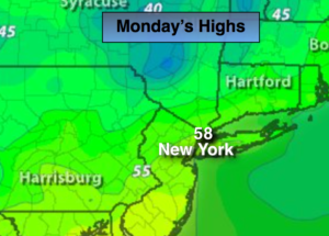
Today:
Sun will give way to mostly cloudy skies. A stray shower is possible, chilly. Highs in the upper 50s. West to Northwest winds at 10-15mph.
Tonight:
Spotty showers early, otherwise partly cloudy. Cold. Lows in the mid 40s in the City, the 30s inland. Northwest winds at 5mph.
Tuesday:
Partly sunny. Highs around 60º.
Wednesday:
Partly sunny. Highs in the lower 60s.
Thursday:
Partly sunny. Highs in the lower to mid 60s.
Friday:
Partly sunny. Highs in the lower to mid 60s.
Keep it here for a no nonsense, no hype forecast.