Synopsis:
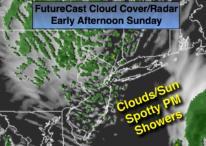
The storm responsible for our changeable, cool conditions this weekend will continue to slowly pull into Eastern Canada. The system has a large circulation and will continue to affect the area. Today will start off with some sun but the clouds and spotty showers will roll in by later in the morning and continue on and off through the afternoon. Eastern section may stay in the sunshine for a longer period of time (FutureCast Cloud Cover/Radar above).
The cool readings will stay with us for the majority of the upcoming week with mainly dry conditions as a Northwesterly flow aloft continues.
Stay tuned.
Today:
A few hours of morning sun otherwise becoming mostly cloudy with spotty showers, cool. Parts of Long Island and Connecticut will have the sun for a longer period of time. Highs around 60º. Southwest to West winds at 10-20mph.
Tonight:
Spotty showers early, otherwise partly cloudy. Cold. Lows in the lower to mid 40s in the City, the 30s inland. West winds at 5-10mph.
Monday:
Clouds and sun. A stray shower is possible, chilly. Highs in the upper 50s.
Tuesday:
Partly sunny. Highs in the upper 50s.
Wednesday:
Partly sunny. Highs in the lower 60s.
Thursday:
Partly sunny. Highs in the mid 60s.
Keep it here for a no nonsense, no hype forecast.