Synopsis:
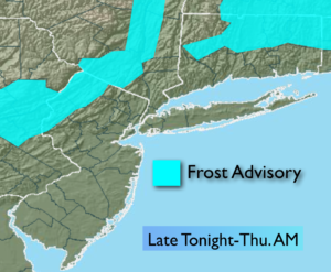
Cold high pressure will move over the region tonight. Winds will relax and temperatures will drop into the 30s this will allow for frost formation well inland. A Frost Advisory has been posted for areas to the North and West.
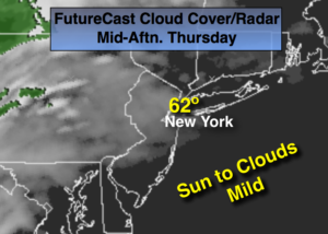
The high will slip offshore on Thursday as a storm will develop over the South. The system will throw high clouds our way. Morning sun will give way to increasing clouds during the day. The low will move up the Appalachians on Friday with rain, which could be heavy at times.
The storm will slow down over Northern New England over the weekend and keep the threat of showers in the forecast. It will not be a washout. The best chance of showers looks to be Saturday afternoon into the evening. I’m just the messenger.
Stay tuned.
Tonight:
Clear and chilly. Lows in the mid to upper 40s in the City, the 30s inland. Patchy frost is possible well inland. Northwest wind at 5-10mph and diminishing.
Thursday
Morning sun will give way to increasing clouds. Highs in the lower 60s. Northeast to Southeast winds at 10-15mph.
Friday:
Rain likely. Highs in the mid 60s.
Saturday:
Mostly cloudy. Scattered afternoon showers. Highs in the mid 60s.
Sunday:
Mostly cloudy with spotty showers, very cool. Highs in the upper 50s.
Monday:
Sun and clouds, chilly. Highs in the mid 50s.
Keep it here for a no nonsense, no hype forecast.