Synopsis:
After a frosty morning inland a pleasantly cool day is expected. The high pressure system will slip offshore as a storm develops over the South. The system will throw high clouds our way. Morning sun will give way to increasing clouds during the day. The low will move up the Appalachians on Friday with rain, which could be heavy at times.
The storm will slow down over Northern New England over the weekend and keep the threat of showers in the forecast. It will not be a washout. The best chance of showers looks to be Saturday afternoon into the evening. I’m just the messenger.
Stay tuned.
Today:
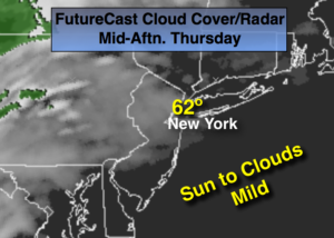
Morning sun will give way to increasing clouds. Highs in the lower 60s. Northeast to Southeast winds at 10-15mph.
Tonight:
Thickening clouds. Light rain is possible after midnight. Lows around 50º. Southeast to East wind at 8-12mph.
Friday:
Rain and possible thunderstorms. The rain could be heavy at times. Highs in the lower to mid 60s.
Saturday:
Mostly cloudy. Scattered afternoon showers. Highs in the mid 60s.
Sunday:
Mostly cloudy with spotty showers, very cool. Highs in the upper 50s.
Monday:
Sun and clouds, chilly. Highs in the mid 50s.
Keep it here for a no nonsense, no hype forecast.