Synopsis:
Low pressure in Eastern Canada combined with High pressure over the Great Lakes with result in a brisk Northwest wind & cooler readings today. The sun will dominate the next two days as the high moves over the region. Patchy frost is possible inland in the sheltered valleys tonight.
An storm will develop over the South Thursday and move up the Appalachians Friday. The rain could be heavy at times.
The storm will slow down over Northern New England over the weekend and keep the threat of showers in the forecast. It will not be a washout. The best chance of showers looks to be Saturday afternoon into the evening. I’m just the messenger.
Stay tuned.
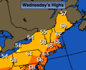
Today:
Mostly sunny. Highs in the lower 60s. West wind at 10-20mph with higher gusts.
Tonight:
Clear and chilly. Lows in the mid to upper 40s in the City, the 30 inland. Patchy frost is possible North and West. Northwest wind at 5-10mph.
Thursday
Partly sunny. Highs in the mid 60s.
Friday:
Rain likely. Highs in the mid 60s.
Saturday:
Mostly cloudy. Scattered mid-day and afternoon showers. Highs in the mid 60s.
Sunday:
Mostly cloudy with spotty showers, very cool. Highs in the upper 50s.
Keep it here for a no nonsense, no hype forecast.