Synopsis:
A warm front will approach tonight with areas of dense fog and drizzle.
Monday-May’s debut, will start off grey with areas of drizzle and fog. The clouds will break for some sun by mid-day. Temperatures will once again spike ahead of a cool front. Showers and thunderstorms are likely Monday night. Readings will come down in steps midweek with fair conditions.
The threat of heavy rain exists late week with a storm riding up the coast.
Stay tuned.
Tonight:
Cloudy with areas of dense fog and drizzle. Lows in the upper 40s to lower 50s. East wind at 5-10mph.
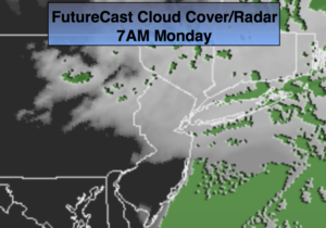
Monday:
Morning drizzle and fog will give way to some sun. Warmer and breezy. Highs 75º-80º. Cooler at the coast. Southeast to South wind at 15-2m5ph.
Tuesday:
Partly sunny. mild. Highs in the lower 70s.
Wednesday:
Partly sunny. Seasonal. Highs in the mid 60s.
Thursday:
Sun to clouds. Highs in the lower 60s.
Friday:
Rain likely. Highs in the lower 60s.
Keep it here for a no nonsense, no hype forecast.