Synopsis:
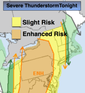
Today-May’s debut, will start off grey with areas of drizzle and fog. The clouds will break for some sun by mid-day. Temperatures will once again spike ahead of a cool front. Showers and thunderstorms are likely tonight. Some of the storms may become severe (map above). Readings will come down in steps midweek with fair conditions.
The threat of heavy rain exists late week with a storm riding up the coast on Friday.
Stay tuned.
Today:
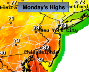
Morning drizzle and fog will give way to some sun. Warmer and breezy. Highs 75º-80º. Cooler at the coast. Southeast to South wind increasing to 15-25mph.
Tonight:
Cloudy with scattered showers and thunderstorms. Some of the storms maybe severe with damaging wind gusts.. Lows in the upper 50s to lower 60s. South to West wind at 15-25mph.
Tuesday:
Partly sunny. mild. Highs in the lower 70s.
Wednesday:
Partly sunny. Seasonal. Highs in the mid 60s.
Thursday:
Sun to clouds. Highs in the lower 60s.
Friday:
Rain likely. Highs in the lower 60s.
Keep it here for a no nonsense, no hype forecast.