Synopsis:
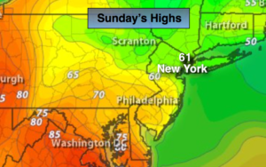
April’s finale will feature much cooler air as a backdoor cool pushes Southwest. Winds blowing off the cold Atlantic will cause the dramatic shift in temperatures. Highs will be twenty five degrees cooler than Saturday under mostly cloudy skies.
A warm front will approach tonight with areas of dense fog and drizzle.
Monday will start off grey with areas of drizzle and fog. The clouds will break for some sun by mid-day. Temperatures will once again spike ahead of a cool front. Showers and thunderstorms are likely Monday night. Readings will come down in steps midweek with fair conditions.
The threat of heavy rain exists late week with a storm riding up the coast.
Stay tuned.
Today:
Mostly cloudy. Much cooler. Highs around 60º. Slightly warmer inland, slightly cooler at the coast. The average high temperature for the date is 66º. East winds at 10-20mph.
Tonight:
Cloudy with areas of dense fog and drizzle. Lows in the upper 40s to lower 50s. East wind at 5-10mph.
Monday:
Morning drizzle and fog will give way to some sun. Warmer. Highs 75º-80º. Cooler at the coast.
Tuesday:
Partly sunny. mild. Highs in the lower 70s.
Wednesday:
Partly sunny. Seasonal. Highs in the mid 60s.
Thursday:
Mostly cloudy with showers. Highs in the lower 60s.
Keep it here for a no nonsense, no hype forecast.