Synopsis:
There will be a brief break from the wet weather today as the sun returns with a ridge of high pressure. It’ll be warmer than recent days.
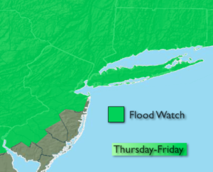
Storm #2 will move in Thursday with more rain and flooding concerns. A Flood Watch has been posted for much of the tri-state area. One to two inches of rain is possible during that time frame which could cause streams, creeks and possibly main stem rivers to overflow their banks. That storm will slowly pull away Friday and allow for improving conditions for the weekend.
Stay Tuned.
Today:
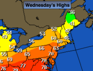
Partly sunny, warm. Highs in the mid 60s. Northwest to Southeast winds at 5-10mph.
Tonight:
Thickening clouds. Rain developing after midnight. Lows in the 40s. East winds at 10-15mph.
Thursday:
Periods of rain, possibly heavy at times.. Highs in the upper 50s.
Friday:
Mostly cloudy, cooler. Spotty showers. Highs in the lower 50s.
Saturday:
Sun and clouds. Highs in the lower to mid 50s.
Sunday:
Mostly sunny and warmer. Highs in the lower to mid 60s.
Keep it here for a no nonsense, no hype forecast.