Synopsis:
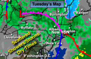
The steadiest and heaviest rain has moved offshore early this morning. For this reason the Flood Watch has been canceled. A spot shower can’t be ruled out for the rest of the morning hours. As an upper level disturbance moves in this afternoon scattered showers and thunderstorms are possible. Some of the storms may contain local downpours and gusty winds. The storm responsible for our wet weather will pull out in the evening bringing an end to the rain.
There will be a brief break in the rain on Wednesday as the sun returns. Storm #2 will move in Thursday with more rain and flooding concerns.
Stay Tuned.
Today:
The steadiest and heaviest rain will move over Long Island and offshore early this morning. There will be dry times mid-morning through early afternoon. Scattered showers and thunderstorms will move in during the afternoon with local downpours. Mild. Highs will be in the 50’s North and East the 60s South and West of the City. Southeast to West winds at 8-12mph.
Tonight:
Partly cloudy. Lows in the lower 50s in the City, the upper 40s inland. West winds at 10-15mph.
Wednesday:
Partly sunny, warm. Highs in the mid 60s.
Thursday:
Periods of rain, possibly heavy at times.. Highs in the upper 50s.
Friday:
Mostly cloudy, cooler. Spotty showers. Highs in the lower 50s.
Saturday:
Mostly cloudy, cool. Highs in the lower to mid 50s.
Keep it here for a no nonsense, no hype forecast.