Synopsis:
It will all depend on your location today to whether you see temperatures in the 40s or near 70º. A backdoor cold front will work in during the day and keep areas to the North cool and cloudy while areas to the South of the front will be much warmer. Of course, the front will set up right over the immediate New York City area. Skies will be mostly cloudy with limited sunshine. Scattered showers are likely from mid-day into the afternoon.
On Sunday a stationary front will be to our South with on and off showers. The latest computer guidance suggests not a lot of rain will fall. The wind will be off the cold Atlantic keeping readings only in the 40s.
Unsettled times will be with us Monday and Tuesday with a series of low pressure systems affecting the trip-state area.
Stay Tuned.
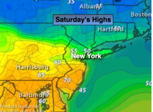
Today:
Mostly cloudy. Showers are possible during the afternoon. Highs in the 40s North, the 50s in the immediate NYC vicinity and the 60’s to near 70º South. West wind will become Northeast at 5-10mph.
Tonight:
Cloudy with areas of light rain and drizzle. Patchy fog. Lows in the 30s throughout. Northeast wind at 5-10mph.
Sunday:
Mostly cloudy with on and off light rain and drizzle. Much colder. Highs in the 40s.
Monday:
Periods of rain with highs around 50º.
Tuesday:
Mostly cloudy with showers possible. Highs in the 50s.
Wednesday:
The sun returns. Highs near 60º.
Stay Tuned.
Keep it here for a no nonsense, no hype forecast.