Synopsis:
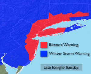
***Blizzard Warning is in effect for all of New York City, much of Long Island, coastal Connecticut & Eastern NJ. Winter Storm Warnings are in effect for the remainder of the tri-state area for late tonight and Tuesday***
Today will be the calm before the storm. High pressure will remain over the Northeast and continue to maintain the cold air that has been in place.
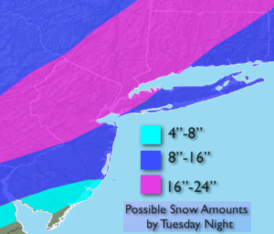
The latest computer guidance suggests that the storm potential will become a reality as all of the models have epic amounts of snow on the way. The models show the storm is stronger and has higher precipitation amounts. The snow will get going around midnight and come down heavy at times later tonight and Tuesday morning. Snowfall rates of 1″-3″ and hour are likely. The brunt of the storm will be from 4AM-Mid-day Tuesday. Thunder snow is possible with whiteout conditions. Coastal flooding is possible at times of high tides on Tuesday. Winds will gust between 40-60mph on the coast. Scattered power outages are a concern do to the highs winds and heavy wet snow that may bring down tree limbs.
A few questions that still need to be answered and probably won’t get answer until just before the storm gets going is: How much mixing occurs along the coast? Where does the heaviest precipitation banding set up?
Stay tuned.
Today:
Mostly sunny and chilly. Highs in the mid 30s. Northwest to Southeast wind at 5mph.
Tonight:
Snow developing around midnight. The snow will become heavy at times. Lows in the mid 20s in the City, around 20º inland. Winds becoming Northeast and increasing to 15-30mph.
Tuesday:
Snow. Heavy at times. A mix at times at the coast. Very windy, especially at the coast. Highs around freezing.
Wednesday:
Mostly cloudy. Snow showers. Windy and cold. Highs around freezing.
Thursday:
Partly sunny, breezy and cold. Highs in the mid 30s.
Friday:
Partly sunny, breezy and chilly. Highs in the upper 30s.
Stay Tuned.
Keep it here for a no nonsense, no hype forecast.