Synopsis:
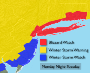
***Blizzard Watch is in effect for all of New York City, Long Island, coastal Connecticut & Northeastern NJ. Winter Storm Warnings & Watches are in effect for the remainder of the tri-state area for late Monday Night and Tuesday***
Tonight and Monday will be the calm before the storm. High pressure will remain over the Northeast and continue to maintain the cold air that has been in place.
The latest computer guidance suggests that the storm potential will become a reality as all of the models have a good hit of snow. Some models have monster amounts while a few have lesser amounts, but still significant. A few questions that still need to be answered and probably won’t get answer until just before the storm gets going is: How much mixing occurs along the coast? Where does the heaviest precipitation banding set up?
A Blizzard Watch has been posted for the possibility of blizzard conditions (heavy snow and high winds) from NYC vicinity and to the East. Winter storm warnings are up most of the remainder of the region for the likelihood of significant snowfall. A Winter storm watch is in effect for coastal NJ for the possibility of significant snow.
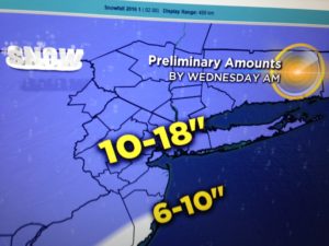
Confidence continues to increase that much of the region will experience a major snowstorm. Possible snow amounts are above. These amounts are a generalization and will most likely change as we get closer to the onset of the storm. The snow will begin Monday Night and wind down Tuesday Night.
Stay tuned.
Tonight:
Mostly clear and cold. Lows around 20º in the City, the teens and single digits inland. Northwest winds diminishing to 5mph or less.
Monday:
Mostly sunny and chilly. Highs in the mid 30s. Northwest to Southeast wind at 5mph.
Tuesday:
Snow or a mix, heavy at times. Very windy, especially at the coast. Highs around freezing.
Wednesday:
Mostly cloudy. Snow showers. Windy and cold. Highs around freezing.
Thursday:
Partly sunny, breezy and cold. Highs in the mid 30s.
Friday:
Partly sunny, breezy and chilly. Highs in the upper 30s.
Stay Tuned.
Keep it here for a no nonsense, no hype forecast.