Synopsis:
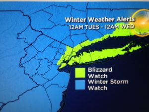
***Blizzard Watch is in effect for all of New York City, Long Island, coastal Connecticut & Northeastern NJ. A Winter Storm Watch is in effect for the remainder of the tri-state area for late Monday Night and Tuesday***
An Arctic airmass will be over the region this weekend. Temperatures will be well below average with highs most likely remaining below freezing Saturday and getting to around freezing on Sunday. Both days will feature a mix of sun and clouds.
The potential storm is on the map for Tuesday. The ingredients are there for a significant snowfall for many areas (or a mix at times at coast). Will it all come together? The signals are there for a large, intense storm. It’s the details that need to be ironed out. How much mixing occurs along the coast? Where does the heaviest precipitation banding set up?
A Blizzard Watch has been posted for the possibility of blizzard conditions (heavy snow and high winds) from NYC vicinity and to the East. Winter storm watches are up elsewhere for the possibility of significant snowfall. A watch means just that we watch the situation. It is not a warning.
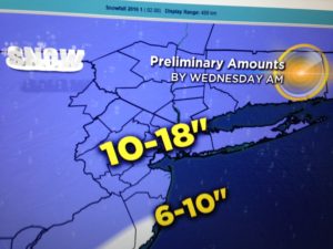
Confidence continues to increase that much of the region will experience a major snowstorm. Possible snow amounts are above. These amounts are a generalization and will most likely change as we get closer to the onset of the storm. The snow will begin Monday Night and wind down Tuesday Night.
Stay tuned.
Today:
Partly sunny and cold. Highs around freezing. Northwest winds at 10-20mph.
Tonight:
Mostly clear and cold. Lows in the lower 20s in the City, the teens inland. Northwest winds at5-10mph.
Monday:
Mostly sunny and chilly. Highs in the mid 30s.
Tuesday:
Storm Potential. Snow or a mix, heavy at times. Highs around freezing.
Wednesday:
Mostly cloudy. Snow showers. Windy and cold. Highs around freezing.
Thursday:
Partly sunny, breezy and cold. Highs in the mid 30s.
Stay Tuned.
Keep it here for a no nonsense, no hype forecast.