Synopsis:
An Arctic airmass will be over the region this weekend. Temperatures will be well below average with highs most likely remaining below freezing Saturday and getting to around freezing on Sunday. Both days will feature a mix of sun and clouds.
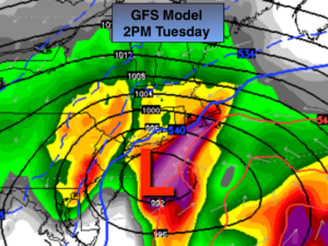
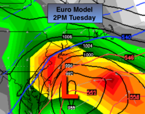
There is a potential storm on the horizon for Tuesday. The ingredients are there for a significant snowfall for many areas (or a mix at times at coast). Will it all come together? The signals are there for a large, intense storm. It’s the details that need to be ironed out. Those details will make all the difference in the world between a snow/rain mix or a raging snowstorm. The latest computer guidance of our two main models are more similar now, so confidence has increased on the storm threat. Both the GFS and European models above show an intensifying storm off the NJ coast Tuesday with heavy snow and a heavy mix at the coast. This is taking both of these models verbatim. Yes, the confidence is increasing that many areas will see significant snow with a mix at the coast. Snow amounts will not be given out yet as the system is still 3 days away. Those that are giving out numbers are not reliable.
Stay tuned.
Today:
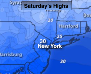
Partly sunny, windy and cold. Highs around 30º. Wind chills in the teens and 20s. Northwest wind at 15-30mph with higher gusts.
Tonight:
Mostly clear and bitterly cold. Lows in the upper teens in the City, the lower teens inland. Northwest wind at 15-25mph and diminishing. Wind chill factors will be near zero.
Sunday:
Partly sunny and cold. Highs in the lower to mid 30s.
Monday:
Mostly sunny and chilly. Highs in the mid 30s.
Tuesday:
Storm Potential. Snow or a mix, heavy at times. Highs around freezing.
Wednesday:
Becoming partly sunny, windy and cold. Highs around freezing.
Stay Tuned.
Keep it here for a no nonsense, no hype forecast.