Synopsis:
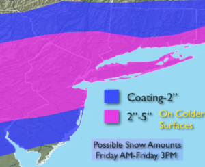
A cold front with a wave of low pressure will move through the region today with a period of snow. The snow may begin as rain over the City and to the South early this morning but will quickly go over to snow. It will be a quick hitter with the snow ending by mid-day or early afternoon. 2″-5″ is expected on colder surfaces with lighter amounts to the North and South of this band (map above). Eastern Long Island may approach 6″. For this reason a Winter Storm Warning has been issued. The morning commute will become treacherous where the heaviest snow falls. The sun may make an appearance later in the day inland.
The flood gates will open up from Canada and cold air will funnel into the area this weekend. Temperatures will be well below average with highs most likely remaining below freezing Saturday and getting just above freezing on Sunday.
There is another potential storm on the horizon for Tuesday. The ingredients are there for a decent snowfall, will they all come together? Plenty of time to watch this one. Yep, key word- POTENTIAL. Stay tuned.
Today:
Snow likely. The snow will taper off during mid-day to early afternoon from West to East. Late day sun is possible. Highs in the upper 30s. North to Northeast winds becoming Northwest at 10-20mph with gusts to 30mph later today.
Tonight:
Mostly clear and bitterly cold. Lows in the upper teens in the City, the lower teens inland. Northwest wind at 15-30mph with gusts to 35mph. Wind chill factors will be near zero.
Saturday:
Partly sunny, windy and cold. Highs around 30º. Wind chills in the teens and 20s.
Sunday:
Partly sunny and cold. Highs in the lower to mid 30s.
Monday:
Mostly sunny and chilly. Highs in the mid 30s.
Tuesday:
Snow Possible. Highs around freezing.
Stay Tuned.
Keep it here for a no nonsense, no hype forecast.