Synopsis:
***Blizzard & Winter Storm Warnings are in effect for inland areas Today***
Blizzard is defined as:
1)Heavy falling Snow or blowing snow
2)Visibility below 1/4mile
3)Winds in excess of 35mph
These conditions need to persist for 3 or more consecutive hours.
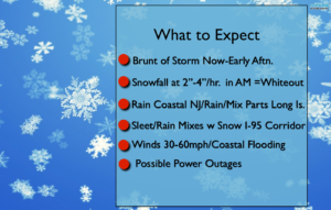
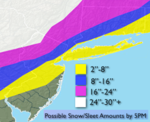
The latest computer guidance continues to suggest that epic amounts of snow are likely for areas North & West of New York City (potential snow amounts, warnings and What to Expect graphics are above). The storm will be going through bombogenesis (a rapidly intensifying storm where the pressure falls are very dramatic) just off the coast of NJ. This will bring Snowfall rates of 2″-4″ and hour over inland areas this morning. The brunt of the storm will be from now into mid-day. Thunder snow is possible with whiteout conditions. The latest models show the intense storm now hugging the coast of NJ and Long Island. Because of this development with the track of the storm coastal NJ many areas have gone over to rain or sleet. This will cut back on snow amounts greatly. Areas from the City and Eastward into Long Island will experience this warming as well, resulting in a cutback in snow totals.
Coastal flooding is possible at times of high tides. Winds will gust between 40-60mph on the coast and to 35-40 mph inland. Scattered power outages are a concern do to the highs winds and heavy wet snow that may bring down tree limbs.
Please be safe.
Stay tuned.
Today:
Snow. Heavy at times inland. Heavy sleet back to snow later this morning along the I-95 corridor. Windswept rain along the coast. Very windy, especially at the coast. Highs around freezing. Northeast to Northwest wind at 15-35mph gusts to 60mph at the coast.
Tonight:
Leftover snow showers are times otherwise mostly cloudy. Lows around 20º in the City, the teens inland. Northwest winds at 15-30mph with higher gusts.
Wednesday:
Mostly cloudy. Snow showers. Windy and cold. Highs around freezing.
Thursday:
Partly sunny, breezy and cold. Highs in the mid 30s.
Friday:
Mostly sunny and chilly. Highs in the upper 30s.
Saturday:
Mostly cloudy. Scattered snow showers. Highs around 40.
Stay Tuned.
Keep it here for a no nonsense, no hype forecast.