Synopsis:.
This Winter will be dubbed “The Rollercoaster” as we’ve seen so many ups and downs in temperature. Personally, I have not experienced a Winter like this in the tri-state area with such temperature swings.
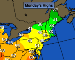
The return flow around the high pressure system that gave us our cold weekend will provide for seasonal readings to start the workweek. Another Spring Fling will be upon us by Tuesday. It’ll feel more like April with scattered showers.
Looking down the pike the models are in a state of disarray from Friday through the weekend. There will be cold high pressure to the North. One or two areas of low pressure may affect the area. How these systems interact is anybody’s guess right now. Stay tuned.
Today:
Partly sunny. Seasonal. Readings will be in the mid 40s. Winds will become South at 5-10mph.
Tonight:
Mostly cloudy with scattered showers. Much milder than recent nights. Lows around 40º in the City, near freezing inland. Light Southeast wind.
Tuesday:
Mostly cloudy with on and off showers. The showers are most likely later in the day. Balmy. Highs around 60º.
Wednesday:
Partly sunny and still mild. Highs in the 50s to around 60º.
Thursday:
Partly sunny, more seasonal. Highs in the mid to upper 40s.
Friday:
Mostly cloudy. A few showers are possible. Highs in the mid 40s.
Stay Tuned.
Keep it here for a no nonsense, no hype forecast.