Synopsis:.
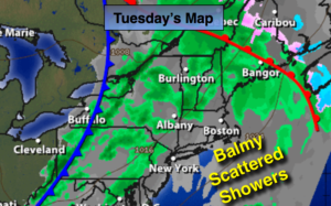
A warm front will work toward the area and swing to our North later today. Another Spring Fling will be upon us. On and off rain and showers is expected today. Tomorrow will be balmy as the cold air is lagging behind the front.
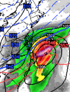
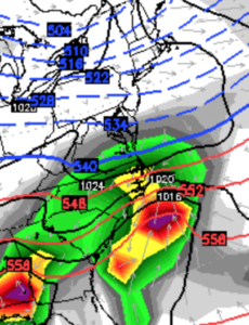
Looking down the pike there are two areas of low pressure to watch. The first, on Friday will a weak system. Scattered snow showers are possible. The second storm potential will be on Sunday. This system will be more potent. The track of this low pulling out of the South is still in question. The models have now converged on a solution that the storm will pass to our South. The second map above is the GFS, the 3rd the European model. At this point it looks like a miss but stay tuned as we have many days to watch this system develop. One thing is for sure it will be a very cold weekend.
Today:
Mostly cloudy with on and off showers. Mild. Highs in the mid 50s.
Tonight:
Periods of rain. Very mild with lows in the 40s to around 50º. Southwest wind at 10-15mph.
Wednesday:
Partly sunny and balmy. Highs around 60º.
Thursday:
Partly sunny, more seasonal. Highs in the mid to upper 40s.
Friday:
Mostly cloudy. A few snow showers are possible. Highs in the lower 40s.
Saturday:
Partly sunny and cold. Highs around freezing.
Stay Tuned.
Keep it here for a no nonsense, no hype forecast.