Synopsis:.
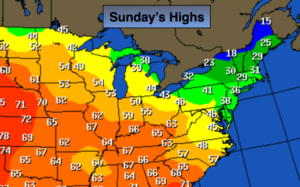
Canadian high pressure moving into the area is the culprit behind this bitter airmass. This morning will be frigid with readings in the single digits and teens. Wind chills will be in the single digits along the coast, near 0º or below inland. By this afternoon temperatures will recover slowly to above freezing with high pressure overhead and much lighter winds; it won’t be as harsh. The mild temperatures over the midwest on the map above will be heading in our direction for early next week. Another Spring Fling will be upon us. The next chance of rain will be Tuesday.
Looking down the pike the models are in a state of disarray from Friday through the weekend. There will be cold high pressure to the North. One or two areas of low pressure may affect the area. How these systems interact is anybody’s guess right now. Stay tuned.
Today:
Sunny and cold. Highs in the mid 30s. Northwest wind at 10-15mph.
Tonight:
Clear. Not as cold as last night. Lows upper 20s in the City, single digits inland. Light North wind.
Monday:
Partly sunny. Mild once again. Highs around 50º.
Tuesday:
Mostly cloudy with on and off showers. Balmy. Highs around 60º.
Wednesday:
Partly sunny and still mild. Highs in the lower 50s.
Thursday:
Partly sunny, more seasonal. Highs in the mid to upper 40s.
Stay Tuned.
Keep it here for a no nonsense, no hype forecast.