Synopsis:.
Today high pressure to the South will provide the region with a decent start to the workweek with just above seasonal averages for this time of the year.
A complex storm system will move into the area tomorrow and Wednesday. On and off rain is likely with Spring-like readings.
A new development is on the maps with the latest computer guidance for Thursday morning. Once the cold front moves offshore Wednesday night a wave of low pressure over Texas will ride along the front and off the coast. If the wave is close enough it’s shield of rain and snow may graze coastal areas Thursday morning. This is a low potential at this time but needs to be addressed. Temperatures will go from Spring-like to Winter in a matter of hours so if the precipitation does fall it would be rain changing to snow. Stay Tuned.
Today:
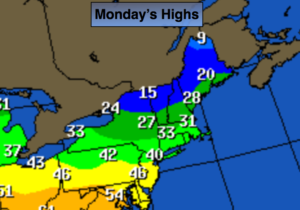
Mostly sunny. Highs in the lower to mid 40’s. Northwest to Southwest wind at 5-10mph.
Tonight:
Increasing clouds. Chance of rain late. Pockets of freezing rain possible well inland. Lows around 40º in the City, near freezing inland. Southwest to Southeast winds at 5mph.
Tuesday:
Periods of rain. Mild. Highs in the upper 40s to lower 50s.
Wednesday:
Mostly cloudy with scattered showers. Balmy. Highs in the mid to upper 50s.
Thursday:
Slight chance of morning snow, especially at the coast, otherwise becoming partly sunny and much colder with readings in the mid 30s.
Friday:
Sunny and cold with highs in the mid 30s.
Stay Tuned.
Keep it here for a no nonsense, no hype forecast.