Synopsis:.
A weak storm will move across the US/Canadian border and into Maine. This system is moisture starved and will result in more clouds today with mild temperatures.
On Monday high pressure to the South will provide the region with a decent start to the workweek.
A complex storm system will move into the area Tuesday and Wednesday. On and off rain is likely with Spring-like readings. Colder readings will push in by late week.
The pattern looks horrible for any snow for the tri-state as we look down the pike.
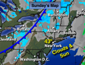
Today:
A mix of clouds and sun. Not as cold. Highs in the lower to mid 40s. Southwest to West winds at 10-20mph.
Tonight:
Partly cloudy. Lows around freezing in the City, the 20’s inland. West to Northwest winds at 8-12mph.
Monday:
Mostly sunny. Highs in the mid 40’s.
Tuesday:
Periods of rain. Mild. Highs in the upper 40s to lower 50s.
Wednesday:
Mostly cloudy with on and off rain. Balmy. Highs in the mid 50s.
Thursday:
Partly sunny and much colder with readings in the mid 30s.
Stay Tuned.
Keep it here for a no nonsense, no hype forecast.