Synopsis:.
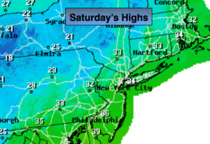
High pressure over the Northern Plains will result in a Northwesterly flow today. Our short-lived cold snap will last one more day. Temperatures will be below seasonal averages. The average high temperature is 39º.
The high will push off the coast on Sunday. At the same time a weak storm will move across the US/Canadian border and into Maine. This system is moisture starved and will result in a few more clouds on Superbowl Sunday with mild temperatures.
A complex storm system will move into the area Tuesday and Wednesday next week. On and off rain is likely. A bit of wintry precipitation is possible Tuesday morning inland. The mix will go over to rain over the interior.
The pattern still looks horrible for any snow for the tri-state as we look down the pike.
Today:
Mostly sunny. Highs around freezing. Northwest to West winds at 10-20mph.
Tonight:
Partly cloudy. Cold. Lows in the upper 20s in the City, the teens inland. West winds becoming Southwest at 5-10mph.
Sunday:
Early sun will give way to clouds. Mild. Highs in the lower to mid 40s.
Monday:
Mostly sunny. Highs in the mid 40’s.
Tuesday:
Periods of rain. Morning wet snow, sleet or freezing rain inland will go over to rain. Highs in the mid 40s.
Wednesday:
Mostly cloudy with on and off rain. Balmy. Highs in the mid 50s.
Stay Tuned.
Keep it here for a no nonsense, no hype forecast.