Synopsis:.
Rapidly changing weather conditions will occur in the next 48 hours. A warm front will push through tonight with rising temperatures and scattered showers. Lows will be higher than the average high for the day.
On Wednesday a cool front will push offshore during the morning with a few showers. The majority of the day will be dry with the sun making an appearance from time to time. The cold air is lagging behind by about one hundred miles. For this reason Spring-like readings are expected. Highs will be around 60º.
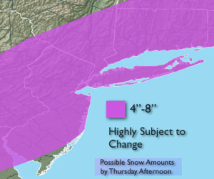
A dramatic change will take place Wednesday night into Thursday. Cold air will rush into the region. At the same time an area of low pressure will move in from the Mid-Atlantic and off the NJ coast. The latest computer models are more robust with the storm’s strength and precipitation. A mix of rain and snow will develop late Wednesday night and turn to snow quickly by early Thursday morning. There is the potential for a plowable snow of 4″-8″+ (map above). The snow could come down heavy at times during the morning. These amounts are highly subject to change but the potential of a significant snowfall has increased. The snow will taper off mid-day to early afternoon. Please Stay Tuned.
Tonight:
Scattered showers, very mild with rising temperatures. Lows around 50º in the City, the 40’s inland. Southeast to Southwest winds at 5-10mph.
Wednesday:
Morning showers, becoming partly sunny. Balmy. Highs near 60º. Southwest to Northwest winds at 10-15mph.
Thursday:
Snow, possibly heavy at times in the morning. The snow will taper off mid-day through early afternoon. Windy. Highs around freezing then falling into the 20s.
Friday:
Sunny and cold with highs around 30º.
Saturday:
Mostly cloudy and seasonal. Highs around 40º.
Sunday:
Mostly cloudy. Scattered showers. Highs in the mid 40s.
Stay Tuned.
Keep it here for a no nonsense, no hype forecast.