Synopsis:.
The winds will finally abate today as the pressure gradient over the Northeast relaxes. Temperatures will be near seasonal averages under partly cloudy skies. In fact, there’s no Arctic air in the contiguous US. Currently, January is the 10th warmest January on record for New York City. Not surprising.
The jet stream is hauling out of the Northwest and there’s really no blocking in Canada to slow the flow down and let any weak area of low pressure form close enough to our region. A few flurries are possible Monday and Tuesday with the trough moving through but thats about it. Southern NJ may get a brief period of light snow for the first half of Monday with a coating of snow possible. It looks tranquil as we head end January and head into the first few days of February.
The next threat and its only that- a threat, is the February 6th-8th time frame. Don’t hold your breath.
Today:
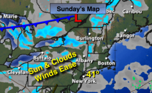
Sun and clouds. Highs around 40º. West wind at 10-15mph.
Tonight:
Partly cloudy. Lows around 30º in the City, near 20º well inland. West to North wind at 5mph.
Monday:
Mostly cloudy, colder. Chance of flurries or snow showers. The best chance is South of the City. Highs in the mid to upper 30s.
Tuesday:
Mostly cloudy with a few flurries or snow showers. Highs in the upper 30s.
Wednesday:
Partly sunny. Highs around 40º.
Thursday:
Partly sunny, colder. Highs in the lower 30s.
Stay Tuned.
Keep it here for a no nonsense, no hype forecast.