Synopsis:.
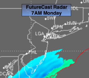
The jet stream is hauling out of the Northwest and there’s really no blocking in Canada to slow the flow down and let any area of low pressure form close enough to our region for a decent snowfall. Southern NJ may get a brief period of light snow for the first half of Monday with a coating of snow possible as a weak system moves quickly offshore (FutureCast Radar above). Another Round of snow showers are possible Tuesday with another impulse moving in. This time the immediate NYC area will experience the flakes. It looks tranquil as we head into the first few days of February.
The next threat and its only that- a threat, is the February 6th-8th time frame. Don’t hold your breath.
Tonight:
Partly cloudy early, mostly cloudy late. Snow showers are possible toward dawn, mainly South of the City. Lows around 30º in the City, near 20º well inland. West to North wind at 5mph.
Monday:
Mostly cloudy, colder. Chance of flurries or snow showers in the morning. The best chance is South of the City. Highs in the mid to upper 30s. North to Northwest winds at 10-15mph.
Tuesday:
Mostly cloudy with a few flurries or snow showers. Highs in the upper 30s.
Wednesday:
Partly sunny. Highs around 40º.
Thursday:
Partly sunny, colder. Highs in the mid 30s.
Friday:
Partly sunny, colder yet. Highs in the lower 30s.
Stay Tuned.
Keep it here for a no nonsense, no hype forecast.